


Challenges Abound as Tropical Storm Henri Hits a Coast with a 30-year Hurricane Gap
Experts in hurricanes, climate and risk perception grapple with ways to boost public safety facing uncertainty


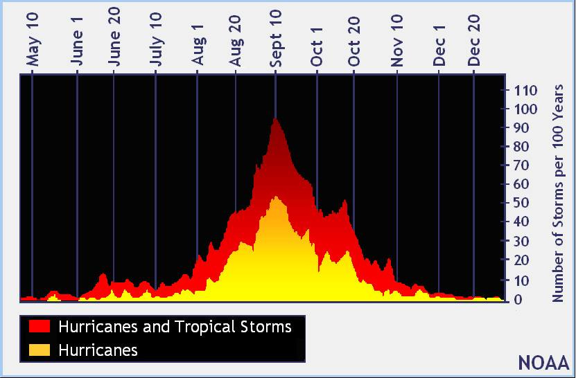
The Atlantic/Caribbean hurricane season is just getting into gear, as you can see in the National Hurricane Center graph above showing the peak. I'll be doing more hurricane/climate coverage this summer. Post questions below in the comments or via this feedback link.
~~
Final update on Henri, August 22, 11:30 a.m. ET - The meandering tropical storm that became Hurricane Henri presented tough challenges to agencies, officials and meteorologists trying to keep people along crowded coasts safe.
If you live in the Northeast, your first stop should always be the National Hurricane Center's constantly-updated website or your local broadcast meteorologist. On Sunday morning, their final pre-landfall forecast showed a near-hurricane-strength system approaching eastern Long Island and Rhode Island, with significant widespread risk from coastal surge and inland flash flooding before the storm turns east.
But if you seek a bit of the back story on how climate and behavioral scientists are trying to improve the responsiveness of communities and officials, please read on and watch and share the discussion below.
If Henri drifts east, the storm could end New England's 30-year hurricane hiatus since Hurricane Bob came ashore at Newport, R.I., and roared up the coast in August 1991. Read this excellent Boston Globe story for lessons that storm offers to New Englanders today. Here are some before-and-after images of damage from that event, from the National Weather Service page for Bob:

When hazards are potentially deadly, but rare, there's serious risk of what experts call "disaster amnesia" setting in and lessening community responsiveness to warnings. Thirty years is a very long time. Read my past coverage of this syndrome, which I've reduced to a phrase - "blah, blah, blah, bang."
But another complication with Henri is that the storm could still strike more than 100 miles west, plowing into Long Island. Since its genesis near Bermuda, this storm has been a wanderer, encountering few of the strong weather systems that sometimes make forecasters' lives easier. Another storm of this sort was Hurricane Sandy, which made a sharp left hook that shaped its destructive impact in and around New York City a decade ago.
Even with supercomputers running an array of models, with tweeting meteorologists and 24/7 news, it's still a challenge to spur communities across such a wide danger zone to take the risk seriously, experts say. On Friday, I organized a Sustain What discussion with some leading researchers working at the interface of hurricane science and behavioral science that determines communities' capacity for preparedness and resilience.
My guests were Rebecca Morss, a senior scientist at the National Center for Atmospheric Research focused on tropical storm forecasts and warning impact; Mary Hegarty, a distinguished professor in psychological and brain sciences at the University of California, Santa Barbara, who runs the school's Spatial Thinking Lab and has led many studies on people's reactions to hurricane warning visualizations; and Adam Sobel, a Columbia Climate School scientist who has deeply researched and communicated Atlantic Ocean hurricane dynamics and risks and wrote "Storm Surge," a gripping book about Hurricane Sandy, science and impacts. Sobel is also contributing live updates to The New York Times on Henri's progress, including one explaining why this storm is unlikely to have an impact like Hurricane Sandy.
I also reached out to J. Marshall Shepherd, a climate scientist and masterful risk communicator at the University of Georgia, for input on this weekend's challenges. "Henri illustrates something that has worried me - a slow-moving tropical cyclone with multi-faceted impacts to the populous Northeast," he wrote. "Sandy was a harbinger. The key thing to remember is there will be impacts anywhere in the cone. It is a common mistake to focus on the center only." Here's Shepherd's tweet to his Forbes post warning that the fading remains of the tropical system Fred are playing a role in how Henri behaves.
I kicked things off in the webcast by playing an animation of the archived National Hurricane Center forecast graphics since the storm formed. The sequence illustrates how the zone of forecast danger around such storms can profoundly shift day to day. We talked about how the "cone" of hurricane risk is misperceived. "Even when I was doing this research myself, I had to keep reminding myself this is not the size of the storm," Hegarty said. "Probability in general is just challenging for people to think about."
Here's a Twitter thread with some more queued-up highlights from our chat.
You can watch the full discussion on YouTube in the window below, on LinkedIn here, or join me on Facebook to discuss this storm and bigger related issues, including the role of climate change in shifting hurricane patterns.