After a Weirdly Quiet First Half, the Atlantic Hurricane Season is in High Gear
Ian is a reminder that all it takes is one hurricane to ruin your day, or city.
Join my Sustain What webcast on next steps for climate policy Friday, August 26th at 1 p.m. Eastern. Read my new post on Ian's assault on Florida: Catastrophe Unfolds as the Tsunami-Like Surge from Category-4 Hurricane Ian Meets Fast-Growing Florida
UPDATE 9/26 - After a surprisingly sleepy first half, the Atlantic hurricane season is in high gear. Ian is the next threat after Fiona's extreme rains scoured Puerto Rico before the still-potent remains of the hurricane struck Nova Scotia with the lowest barometric pressure of any storm in 150 years of record keeping.
Florida is now certain struck this week. Read the latest National Hurricane Center advisory (here as of Monday morning). A lot is riding on that transition the models currently produce from M (major) to H (category 1 or 2) just before landfall. But surge and extreme rainfall are not factored on the current scale of hurricane intensity.
Original post - In a spare moment while tracking U.S. climate policy, the intensifying drought and food crisis in the Horn of Africa, flash floods and more, I squeezed in a pop-up Sustain What conversation with one of my indispensable guides to hurricanes - Brian McNoldy of the University of Miami's Rosenstiel School of Marine, Atmospheric, and Earth Science.
I reached out for two reasons.
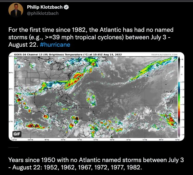
In contrast to late August last year, when Hurricane Henri hit New England and would soon be followed by deadly Hurricane Ida, the Atlantic and Caribbean have been astonishingly quiescent. This is the case despite this Northern Hemisphere summer being extraordinarily extreme in so many other ways. Nearly all tropical forecasters had predicted an active season, in part because of persistent La Niña conditions.
As Phil Klotzbach, another vital source, tweeted, "For the first time since 1982, the Atlantic has had no named storms (e.g., >=39 mph tropical cyclones) between July 3 - August 22."
Second, this summer marks the 30th anniversary of Hurricane Andrew's explosive development into the category five monster that devastated Miami-Dade County, Florida, killing 65 people, wreaking $27 billion in losses, destroying 60,000 homes and damaging 100,000 more - and all of that in the middle of a very sleepy 1992 hurricane season (with only six named storms).
Here's the chilling radar loop resurrected by McNoldy as part of an archive at the University of Miami:
That disaster helped spawn the meteorologists' mantra, "It only takes one."
Because it takes only one, the key steps for any household or community or city are to assess and reduce vulnerabilities (and not just your own!), prepare for the worst, pay attention to forecasts.
This post of mine can help: As Extreme Storms Strike Again, It's Time to Shake out Community Climate Vulnerabilities.
One lesson from Ida, for sure, was that it's vital not to perceive hurricanes only as coastal threats. Deadly flash flooding inland has often been as potent a force as coastal surges - as was the case, tragically, in New York City.
I explored all of this with McNoldy.
He not only does cutting-edge research on the turbulent interface between the ocean and atmosphere (see his publications), but also devotes several hours a day to the vital task of translating tropical cyclone science into information you or I can use to build a safer human relationship with this tempestuous planet.
As he said today in our chat, he began blogging on tropical meteorology in 1996, three years before the word "blog" emerged as a term for a sustained and interactive discussion of an issue. McNoldy told me the first couple of years of posts "are lost to the ages," but here's 1998.
He covered hurricane seasons in different ways for The New York Times and Washington Post.
I hope you'll watch and share the conversation on Facebook or LinkedIn or here on YouTube: "What’s Up With Atlantic Hurricanes, from Andrew in 1992 to Quiet 2022 (so far)?"
Among many questions, I asked, "Is there any way to look at the other dynamics around the world right now - these sustained heat waves, now in China and Europe, particularly, and part of the United States - and what's happening over the Atlantic or is it just too iffy?
McNoldy replied: "It's not completely crazy to imagine that if you have kind of an exaggerated high pressure system over the European countries, that the circulation around that high pressure could act to increase the flow off of northern Africa and out over the Atlantic. I'm not saying it is, because I don't know that yet, but you can at least imagine it in your head. High pressure over Europe would help to enhance the flow over Northern Africa and push even more Saharan air over the Atlantic than what we might normally see."
In our chat I mentioned the Twitter List I developed as my living guide to meteorology through the lens of a batch of great meteorologists like McNoldy. I hope you'll explore. Who's missing? Let me know.
Read
The meteorologist Bob Henson wrote a superb Washington Post overview of lessons learned after Hurricane Andrew, and of the expanding bull's eye of housing and commerce that has sprawled in South Florida since then.


