


A Top Tornado-Focused Meteorologist Issues a Stark Warning About Trump's Weather-Research Cuts

Matthew Cappucci is an invaluable young guide to extreme weather and climate science, both as a writer for the Washington Post’s Capital Weather Gang and through his social media output as part of his work as a senior meteorologist at MyRadar.com.
On Wednesday he posted vital video and written warnings (below) about the dangers posed by the Trump administration’s proposed budget for key weather and climate divisions within the National Oceanic and Atmospheric Administration (which sits in the Commerce Department under Howard Lunick of all people).
He gave permission for me to repost his comments here. Explore below along with related content I’ve added.
Hold onto your hat, and then, yes, call your representatives in Congress, particularly the Republicans. There’s more afoot than the big awful bill.
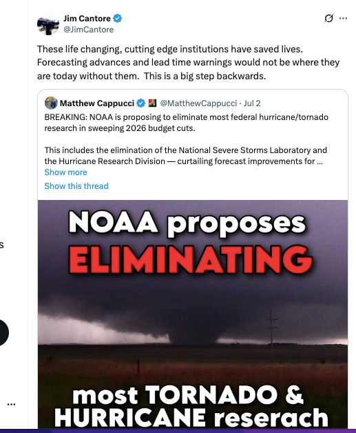
Jim Cantore, the Weather Channel’s superstar severe storm chaser, endorsed what Matt wrote on X, saying, “These life changing, cutting edge institutions have saved lives. Forecasting advances and lead time warnings would not be where they are today without them. This is a big step backwards.” (It’s worth noting Cantore was a longtime critic of overheated global warming proclamations, so he’s not part of the usual choir.)
Here’s Matt Cappucci:
NOAA is proposing to eliminate most federal hurricane/tornado research in sweeping 2026 budget cuts. This includes the elimination of the National Severe Storms Laboratory and the Hurricane Research Division — curtailing forecast improvements for hurricane- and tornado-prone areas.
The National Oceanic and Atmospheric Administration released its proposed budget for 2026 on Monday. Aside from a 17% workforce reduction, the proposal seeks to eliminate OAR — Ocean and Atmospheric Research — an umbrella for most federally-funded weather and climate research.
See the column of 0s…. This is a horrific idea.

Back to Matt:
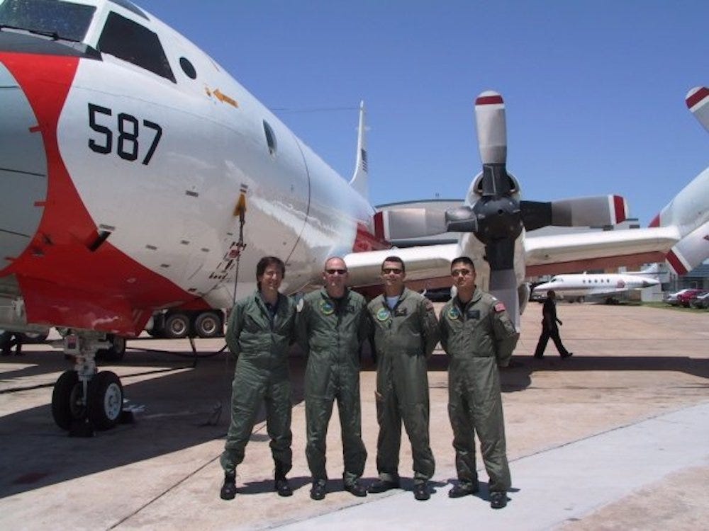
OAR is made up of 10 research laboratories and 16 affiliated cooperative institutes at various universities. One of the laboratories to be shuttered is NSSL, or the National Severe Storms Laboratory in Norman, Oklahoma. They’ve been around for 60 years.
I visited NSSL 15 years ago or so, and got to fly around a severe Oklahoma thunderstorm in a storm-research-converted Lockheed WP3-D submarine hunter aircraft (I’m on the left with abundant un-gray hair). It’s an incredible research hub and I’ve relied on their tornado science and so much more ever since.
As Matt wrote, among other achievement:
They’re the first ones to ever use radar to track a tornado’s life cycle (they did that in Union City, Oklahoma on May 24, 1973).
NSSL was the driver that spurred Congress to approve nationwide weather radar in the 1980s. It’s why we have tornado warnings (those weren’t a thing just a few generations ago). NSSL is currently working on an AI and machine learning-driven program called “Warn on Forecast,” which will use ultra high-resolution weather models that could allow the issuance of tornado warnings HOURS before a thunderstorm even develops. The project “is designed to make probabilistic predictions of individual thunderstorms out to six hours in advance” writes NSSL.
Here’s a fine NOAA explainer of the vital Warn on Forecast research:
It too is on the chopping block.
NSSL has also been working to develop and implement “phased-array radar,” which would allow radars to target individual thunderstorms and scan more rapidly, providing ultra-fast radar scans low within a storm. That would improve tornado detection. (Conventional radars — those dome-like things you see — spin around and around, which adds time to each scan). It’s because of NSSL that we have “dual-polarization” radar, which is what lets us detect debris the instant a tornado touches down.
NSSL is also working on a groundbreaking hail study that is in jeopardy. Hail costs U.S. insurers some $10 billion per year. Understanding how to better forecast it could mitigate that loss and help meteorologists issue better warnings.
Here’s a NOAA video explaining phased-array radar development:
Matt continues:
But that’s just the start of proposed cuts.
NOAA’s proposal would also eliminate the Atlantic Oceanographic and Meteorological Laboratory in Miami. That includes the Hurricane Research Division. The Hurricane Research Division is responsible for developing and maintaining one of our best hurricane-forecasting models — HAFS, or the Hurricane Analysis and Forecasting System. That’s the model that arguably best simulates storms that could rapidly intensify. As meteorologists, we rely heavily on it. It’s unclear what the future of the model would be.
There are also some signs that Hurricane Hunter flights could be limited, though we’re working to learn more details on any specifics. Funding for replacement planes, which have been around since the mid-1970s, is uncertain. The planes were scheduled to be retired and replaced by 2030. Many climate monitoring services and databases could also be suspended.
The American Meteorological Society — the nation’s preeminent body for atmospheric scientists — issued a statement condemning the proposed cuts and warning of concerning consequences. They argue that decisions are being made hastily, offering “little to no opportunity… [for] consideration of long-term impacts.”
They also write “The scientific backbone and workforce needed to keep weather forecasts, alerts, and warnings accurate and effective will be drastically undercut, with unknown — yet almost certainly disastrous — consequences for public safety and economic health.”
We’ll keep you abreast of the latest as we learn more information about proposed changes.
Thanks, Matt, for helping inform the taxpayers who pay for all of this vital work and the communities whose safety now and ahead depends on sustaining it.
Here’s more from other meteorologists tracking the danger in all this demolition:
via : :

Who else are you tracking?
Who needs fireworks? Parting shot
Here’s an extraordinary image of a massive “red sprite” taken July 3 over the Mexico/US border from the International Space Station:
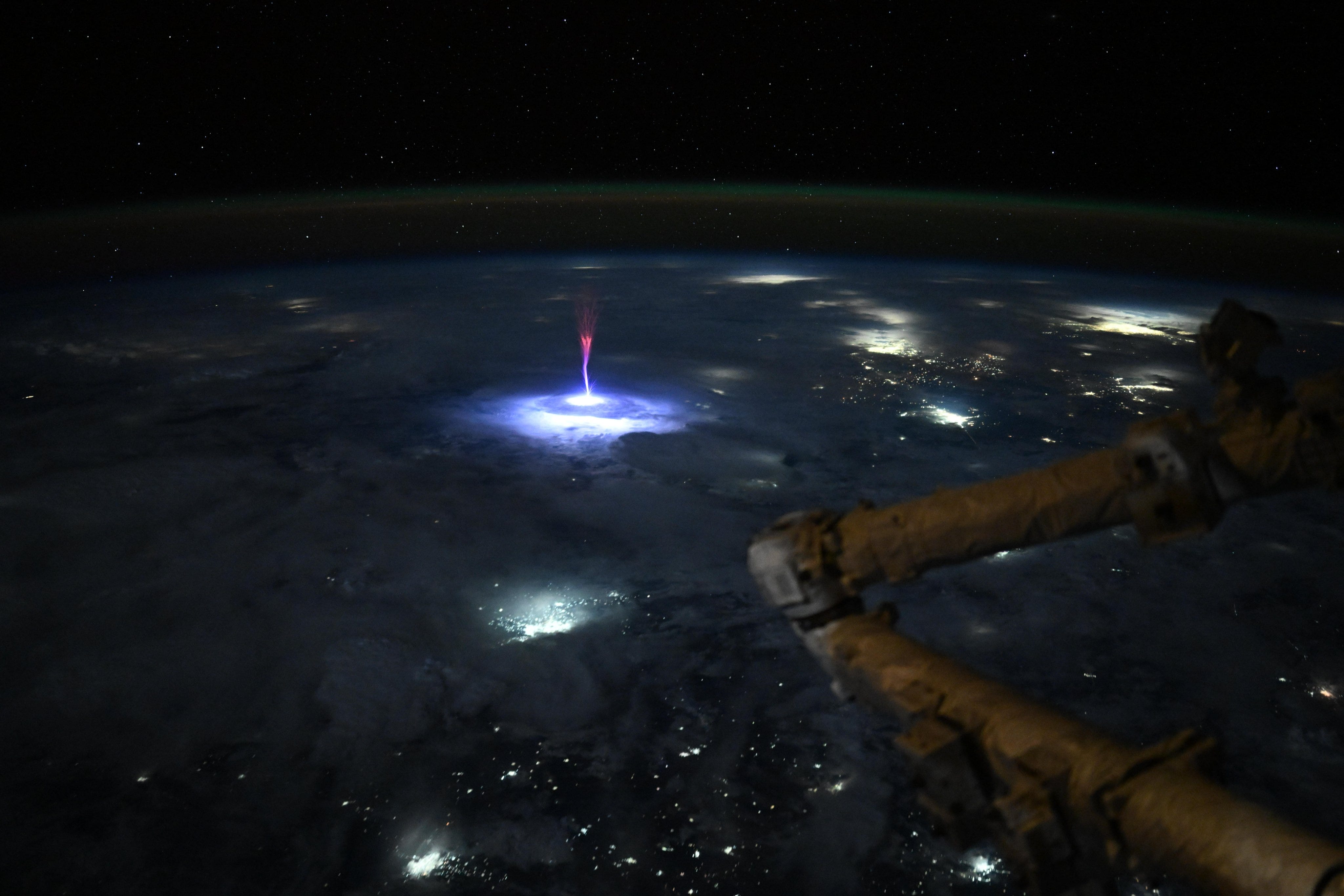
Zoomed:

The image was taken by NASA Astronaut Nichole Ayers, who wrote this on Instagram:
Just. Wow. As we went over Mexico and the U.S. this morning, I caught this sprite.
Sprites are TLEs or Transient Luminous Events, that happen above the clouds and are triggered by intense electrical activity in the thunderstorms below. We have a great view above the clouds, so scientists can use these types of pictures to better understand the formation, characteristics, and relationship of TLEs to thunderstorms.
All that wondderful science…